About the Great Divide Mountain Bike Route
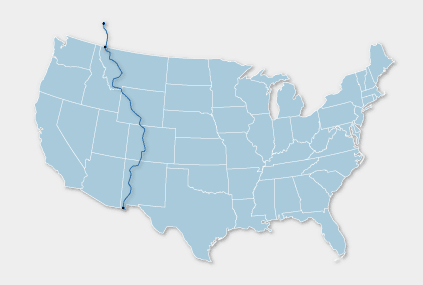
The Great Divide Mountain Bike Route (aka GDMBR) was created by the Adventure Cycling Association. At 2,711 miles, it’s the longest mapped and published off-pavement bike route in the world. The route is generally ridden north to south, crossing the Continental Divide a total of 30 times. Originally it began in Port of Roosville, MT and covered 2,490 miles (4,007 km) to Mexico. In 2003, Adventure Cycling extended the route into Canada. The Canadian segment stretches from Banff, Alberta, to the U.S. segment’s starting point at Port of Roosville; this adds another 221 miles to the route.

Image from adventurecycling.org
The route begins in glacial-carved valleys of Banff National Park in the Southern Canadian Rockies. It passes through the heavily forested mountains of Montanaand Idaho, meanders down into the barren high desert lands ofWyoming’s Great Divide Basin, ascends again up and over several 10,000 to 12,000 foot passes in Colorado, and switch backs through rugged mountainous sections of New Mexico before finally dropping into the Chihuahuan Desert. The majority of New Mexico is forested, not desert. The route’s highest altitude is around 11,910 feet (3,600 m) abovesea level at Indiana Pass in Colorado.
The 2,711 mile trip generally takes around three months for the leisurely rider who stops frequently along the way. Many also choose to complete the route in shorter segments of 1-2 weeks each over several years.
We think we can give it a go in four weeks…but we have been wrong before!